
The Need for GPS Alternatives
GPS, which is owned and operated by the U.S. Air Force, has become an integral part of modern life, supporting a wide range of applications from navigation and mapping to precision timing for critical infrastructure. However, the system has several vulnerabilities:
- GPS signals are relatively weak and can be easily jammed or spoofed
- The system relies on a constellation of satellites that could be targeted in a conflict
- Solar flares and other space weather events can disrupt GPS signals
- GPS does not work well indoors, underground, or in urban canyons
To address these limitations and ensure the resilience of critical infrastructure, the DOT is investing in the development and testing of alternative positioning, navigation, and timing (PNT) technologies.
Potential GPS Alternatives
Several technologies have emerged as potential alternatives or complements to GPS:
Enhanced Loran (eLoran)
eLoran is a terrestrial radio navigation system that operates at low frequencies, making it more resistant to jamming and interference than GPS. It uses a network of ground-based transmitters to provide positioning and timing information.
| Feature | eLoran | GPS |
|---|---|---|
| Operating Frequency | 90-110 kHz | 1.57542 GHz (L1) and 1.2276 GHz (L2) |
| Signal Strength | High (10-100 kW) | Low (50 W or less) |
| Coverage | Regional (1000-1500 km per transmitter) | Global |
| Accuracy | 8-20 meters | 3-5 meters |
| Availability | 99.9% | 95% |
eLoran has been tested in several countries, including the United States, United Kingdom, and South Korea, as a backup to GPS for critical infrastructure and maritime navigation.
Inertial Navigation Systems (INS)
INS use a combination of accelerometers, gyroscopes, and sometimes magnetometers to track the position, orientation, and velocity of an object without external references. They are self-contained and immune to jamming and interference.
| Type | Description | Drift Rate |
|---|---|---|
| Mechanical Gyroscopes | Use spinning rotors to measure rotation | 0.1-1°/hr |
| Optical Gyroscopes | Use the Sagnac effect to measure rotation | 0.01-0.1°/hr |
| MEMS Gyroscopes | Use vibrating microstructures to measure rotation | 1-10°/hr |
While INS can provide accurate short-term navigation, they suffer from drift over time and require periodic updates from external sources like GPS.
Vision-Based Navigation
Vision-based navigation systems use cameras and image processing algorithms to determine the position and orientation of a vehicle or device relative to its surroundings. They can work in GPS-denied environments and provide contextual awareness.
Some techniques used in vision-based navigation include:
- Feature detection and matching
- Visual odometry
- Simultaneous localization and mapping (SLAM)
| Technique | Description | Applications |
|---|---|---|
| Feature detection and matching | Identify and track distinctive features in images | Augmented reality, robotics |
| Visual odometry | Estimate motion from sequential camera images | Autonomous vehicles, drones |
| SLAM | Construct a map of an unknown environment while simultaneously tracking location | Robotics, 3D mapping |
Vision-based navigation can be combined with other sensors like INS and GPS to improve accuracy and robustness.
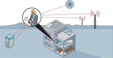
Signals of Opportunity (SoOP)
SoOP refers to the use of existing radio frequency signals, such as cellular, Wi-Fi, and television broadcasts, for positioning and navigation. These signals are more widely available and stronger than GPS, particularly in urban and indoor environments.
| Signal Type | Frequency Range | Positioning Techniques |
|---|---|---|
| Cellular | 700 MHz – 2.6 GHz | Time difference of arrival (TDOA), received signal strength (RSS) |
| Wi-Fi | 2.4 GHz, 5 GHz | Fingerprinting, trilateration |
| Television | 54-890 MHz | Pseudorange, TDOA |
SoOP-based positioning can achieve accuracies of a few meters to tens of meters, depending on the signal type and environment. However, it requires a database of transmitter locations and may be affected by multipath and signal blockage.
DOT’s GPS Backup Demonstration
In 2020, the DOT conducted a GPS backup technology demonstration to evaluate the performance of various alternative PNT technologies in realistic scenarios. The demonstration included:
- eLoran: A modernized version of the legacy Loran-C system, with improved accuracy, availability, and integrity.
- Precision Time Protocol (PTP): A network-based time synchronization protocol that can provide sub-microsecond accuracy over packet-switched networks.
- Inertial Navigation Systems (INS): High-grade inertial sensors combined with visual odometry and mapping to provide continuous navigation in GPS-denied environments.
- Signals of Opportunity (SoOP): Positioning using cellular and low Earth orbit (LEO) satellite signals, with a focus on indoor and urban environments.
The demonstration aimed to assess the readiness and interoperability of these technologies as part of a resilient PNT ecosystem.

FAQ
-
Why is the DOT looking for alternatives to GPS?
The DOT is seeking alternatives to GPS to ensure the resilience and reliability of critical infrastructure that depends on precise positioning and timing. GPS has vulnerabilities, such as susceptibility to jamming and interference, that could disrupt these systems. -
What are some potential alternatives to GPS?
Some potential alternatives or complements to GPS include enhanced Loran (eLoran), inertial navigation systems (INS), vision-based navigation, and signals of opportunity (SoOP) from cellular, Wi-Fi, and television broadcasts. -
How does eLoran differ from GPS?
eLoran is a terrestrial radio navigation system that operates at much lower frequencies than GPS, making it more resistant to jamming and interference. It also has stronger signal strength and better regional coverage, but lower accuracy and global availability compared to GPS. -
Can inertial navigation systems replace GPS?
Inertial navigation systems can provide accurate short-term navigation without external references, but they suffer from drift over time and require periodic updates from external sources like GPS. They are best used as a complement to GPS rather than a complete replacement. -
What is the DOT doing to evaluate GPS alternatives?
The DOT conducted a GPS backup technology demonstration in 2020 to evaluate the performance and interoperability of various alternative PNT technologies, including eLoran, Precision Time Protocol (PTP), inertial navigation systems, and signals of opportunity. The demonstration aimed to assess the readiness of these technologies as part of a resilient PNT ecosystem.
No responses yet